Bird Track Springs Fish Habitat Restoration

GRMW ID: 1944

Fiscal Year: 2017

Project Status:

Complete

Description

Bird Track Springs Fish Habitat Restoration

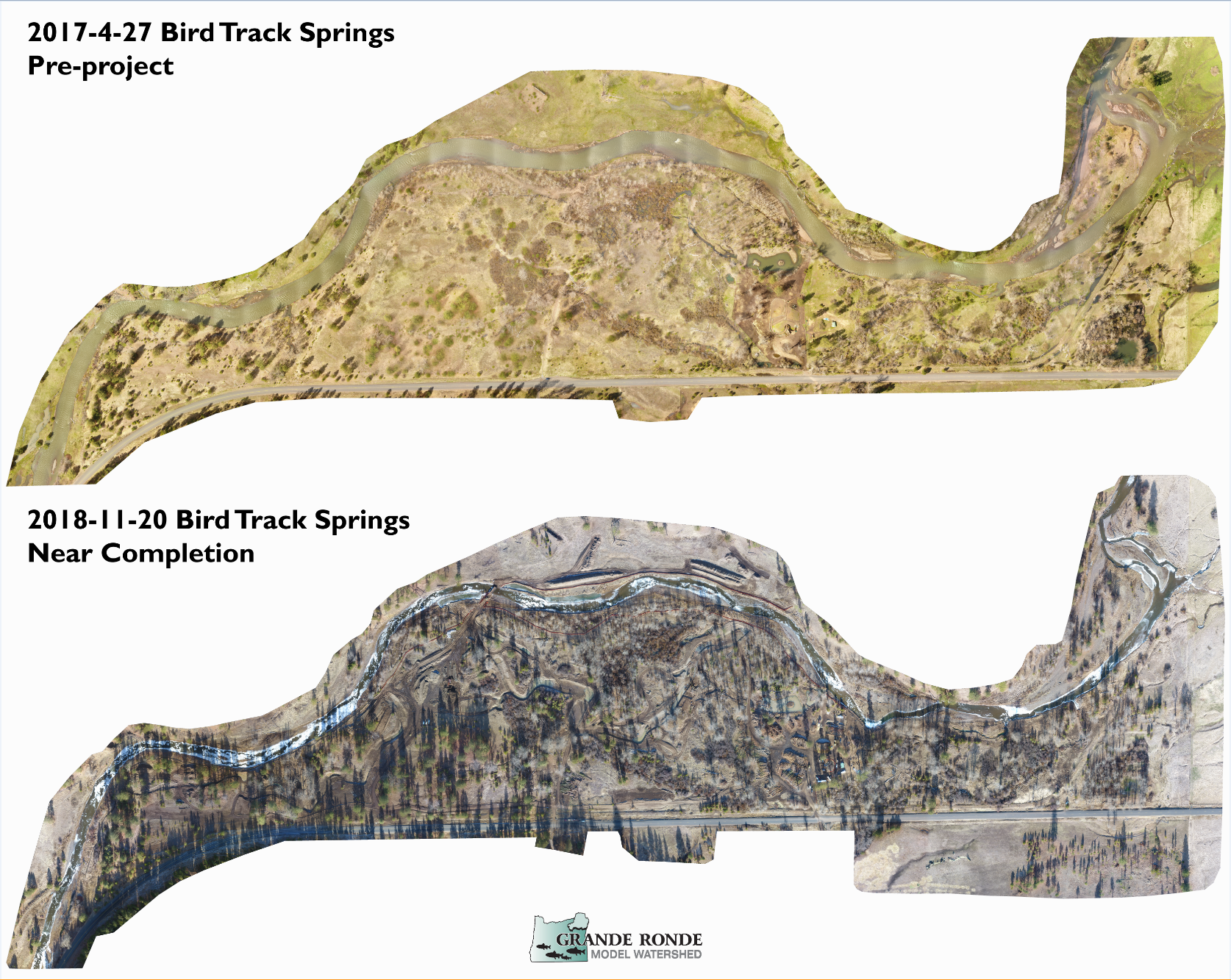
The Bird Track Springs Fish Habitat Enhancement Project is located in the Upper Grande Ronde Subbasin along the mainstem Grande Ronde River between RM 144.7 and 146.1 The Project reach sits at an elevation of approximately 3,100 feet with a contributing watershed area of 475 square miles. The watershed is predominantly snowmelt-driven. Most of the basin is forested (over 73 percent) and has very little development (less than 0.1 percent estimated impervious area) (USGS 2014). The Project reach includes Wallowa-Whitman National Forest and private lands along State Highway 244 within the Grande Ronde recovery plan assessment units UGC3A and UGS16. The Upper Grande Ronde River Tributary Assessment (Appendix A; Reclamation 2014) identifies the Project reach as an unconfined geomorphic reach with a high potential to improve the overall physical and ecological processes that support salmonids in the basin. Severe habitat, floodplain, and channel degradation has occurred as a result of anthropogenic alteration, including beaver trapping, historic splash dam logging ,railroads, road construction, channelization, diking and leeves, and livestock overgrazing. Loss of floodplain forests, wetlands, and natural and complex stream channel networks has promoted plane bed channel morphology which is over-widened and shallow, subject to anchor ice formation, and disconnected from an extensive historic floodplain and channel networik. The project reach exhibits poor habitat quality with elevated stream temperature, lack of large pool habitat, absence of complexity, and limited ability to function properly and provide habitat suitable to support imperiled fishery resources. In the current condition, the middle reaches of the Upper Grande Ronde and incapable to supporting the CTUIR's First Foods policy, exhibits an extreme departure from the CTUIR's River Vision and is not supporting Treaty-Reserved natural resources. Existing riparian vegetation conditions include scattered patches of woody shrubs and deciduous and conifer forest, and large areas of herbaceous vegetation with shallow rooting depths where the floodplain has been cleared and drained for ranching. Beavers are uncommon and no longer play a major role in wood delivery to the channel or maintaining diverse off-channel habitats and riparian and wetland conditions. The long-term rehabilitation vision (CTUIR’s River Vision) for the Bird Track Springs Fish Habitat Enhancement Project is to improve physical and ecological processes by rehabilitating and restoring the project area to achieve immediate and long-term benefits to chinook, steelhead, and bull trout at all life stages.

Project Site Locations

Development Sites

Site name Latitude/Longitude Download
General Site Location 45.302041272707605/-118.30699274775121 Download KML

Contacts & Roles

Name Role Organization
Allen Childs Project Manager Confederated Tribes of the Umatilla Indian Reserv.
David Lowe Landowner Jordan Creek Ranch
Jake Kimbro Technical Contact Confederated Tribes of the Umatilla Indian Reserv.
Jesse Steele Contact Grande Ronde Model Watershed
Aric Johnson Contact La Grande Ranger District
Julie Burke Administrative Contact Oregon Department of Fish & Wildlife
Colleen Fagan Contact Oregon Department of Fish & Wildlife

Organizations

Organization Role
Grande Ronde Model Watershed Cooperator
Confederated Tribes of the Umatilla Indian Reserv. Sponsor
Bonneville Power Administration Funding Entity
Oregon Watershed Enhancement Board Funding Entity

Grants & Contracts

Organization Contract # Funding Amount
Oregon Watershed Enhancement Board 216-8205 $507016.00
Confederated Tribes of the Umatilla Indian Reserv. In Kind $31500.00
Bonneville Power Administration 73982 $2011291.00

Documents

Document Type View Download
Project Proposal View Document Download Document
Other View Document Download Document
Project Prospectus View Document Download Document

Metrics

Metric ID Units Work Elements Metric
1387 2.00 29. Increase Aquatic and/or Floodplain Complexity # of miles of stream with improved complexity
1401 4.00 40. Install Fence # of miles of fence installed in a riparian area
1406 2.00 47. Plant Vegetation, 53. Remove Vegetation, 197. Maintain/Remove Vegetation, 198. Maintain Vegetation, 199. Remove Vegetation # of riparian miles treated
1406 160.00 47. Plant Vegetation, 53. Remove Vegetation, 197. Maintain/Remove Vegetation, 198. Maintain Vegetation, 199. Remove Vegetation # of riparian miles treated
1517 160.00 47. Plant Vegetation, 48. Practice No-till and Conservation Tillage Systems, 53. Remove Vegetation, 180. Enhance Floodplain/Remove, Modify, Breach Dike, 197. Maintain/Remove Vegetation, 198. Maintain Vegetation, 199. Remove Vegetation, 30. Realign, Connect, and/or Create Channel, 31. Conduct Controlled Burn, 52. Remove Mine Tailings, 55. Erosion and Sedimentation Control # of acres of riparian non-wetland habitat treated
1519 114.00 30. Realign, Connect, and/or Create Channel, 47. Plant Vegetation, 53. Remove Vegetation, 197. Maintain/Remove Vegetation, 198. Maintain Vegetation, 199. Remove Vegetation, 52. Remove Mine Tailings, 55. Erosion and Sedimentation Control, 180. Enhance Floodplain/Remove, Modify, Breach Dike # of acres of freshwater non-wetland habitat treated
1549 2.00 40. Install Fence # of miles of left streambank fenced in a freshwater area
1551 2.00 40. Install Fence # of miles of right streambank fenced in a freshwater area
1584 716.00 29. Increase Aquatic and/or Floodplain Complexity # of logjam structures installed for only complexity
1585 60.00 29. Increase Aquatic and/or Floodplain Complexity # of unanchored rocks/boulder structures installed for only complexity
1672 40.00 180. Enhance Floodplain/Remove, Modify, Breach Dike # of acres of habitat treated by full dike removal in the Riparian zone
1681 0.50 180. Enhance Floodplain/Remove, Modify, Breach Dike # of miles of dike removed or modified by Full removal in the Riparian zone
1730 0.50 180. Enhance Floodplain/Remove, Modify, Breach Dike # of miles of dike removed or treated
1743 300.00 40. Install Fence Average buffer width
1748 31.00 29. Increase Aquatic and/or Floodplain Complexity # of pools created for only complexity
1753 2.00 30. Realign, Connect, and/or Create Channel # of miles of main channel treated in the freshwater non-tidal zone
1755 2.00 30. Realign, Connect, and/or Create Channel # of miles of main channel created in the freshwater non-tidal zone
1760 82.00 40. Install Fence # of acres of riparian non-wetland habitat protected by fencing
1626 1.00 40. Install Fence # of other exclusion structures